Space Geodesy Facility News
Recent activities and developments at the SGF.
[7th March 2025]
BGS Recognised as a UN-GGCE Partner
The British Geological Survey has been accepted as

an United Nations Global Geodetic Centre of Excellence (UN-GGCE) Partner.
The UN-GGCE Partnership Program was launched in June 2024 to recognize the
exceptional commitment and significant contributions Member States, universities
and organizations have made to the science of geodesy and strengthening the global
geodesy supply chain.
In 2015, the United Nationas General Assembly adopted resolution 69/266 entitled 'A Global Geodetic Reference Frame for Sustainable Development'. The resolution recognizes the economic and scientific importance of an accurate and stable global geodetic reference frame that allows the interrelationship of measurements taken anywhere on the Earth and in space, combining geometric positioning and gravity field-related observations.
The United Nations initiative on Global Geospatial Information Management (UN-GGIM) recognises the growing need for a high quality and sustainable Global Geodetic Reference Frame (GGRF) to support policy and decision-making for inclusive social progress, environmental sustainability and economic development.
BGS operates a ground observatory at the Space Geodesy Facility, Herstmonceux, which provides critical data and analysis products, including satellite laser ranging, GNSS and absolute gravimetry, to the International Association of Geodesy.
[1st April 2023]
Testing Quantum Gravity Sensors
In collaboration the Quantum Technologies Hub in Sensors and Timing with the University of Birmingham the SGF is working to improve our geodetic data output from our gravity sensors by the removal of hydrological influences on the data. The SGF will be testing new quantum gravity sensors as part of a research grant from EPSRC/NERC.
The testing is important in understanding characteristics/capabilities of the new sensors, such as drift, accuracy and precision, and is essential in developing these sensors.
[21st July 2022]
LARES-2 Launched and SLR Tracking Begins!
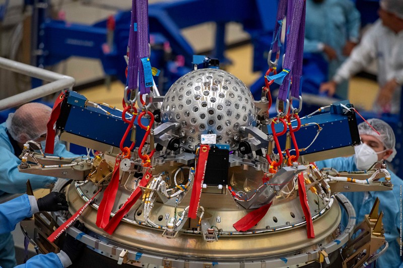
Credit: CNES/ESA/Arianespace/Optique Vidéo CSG/P. Baudon
On 13th July, the new ESA Vega-C rocket successfully delivered a new geodetic spherical target in to orbit at a height of 5,890km above the Earth.
The LAser RElativity Satellite 2, or LARES-2, from ASI (Italian Space Agency) follows on from the first LARES mission, which orbits at a much lower height of 1450 km, and the two LAGEOS satellites.
LARES-2 was positioned with an orbital inclination that is the supplement of that of the LAGEOS satellite so that the combination of observations will better reveal the frame-dragging Lense-Thirring effect.
As with the other geodetic satellites orbitting the Earth, LARES-2 is covered in retro-reflectors. These have been designed to have a small satellite signature and to reduce thermal variations.
The SGF, Herstmonceux was one of 5 SLR stations that were able to track this new target within the first few days after launch, using less accurate orbit predictions calculated from radar tracking.
The SGF Analysis Centre generates precise orbit predictions for a list of ILRS satellites and once SLR data became available for LARES-2 the AC was able to generate
highly accurate predictions to support the global laser ranging community to acquire routine SLR data for this new target. These orbits are generated daily and the SGF has been the primary prediction supplier for the first 2 months of this scientific mission.
With the global tracking network supplying a strong data stream, the AC plans to investigate the inclusion of the new satellite into its research on improving the definition of the global reference frame, including solutions for long-wavelength terms of the Earth’s gravity field.
A full report of the science behind this new satellite and the involvement of the SGF is available here.
[15th April 2021]
Dr Graham Appleby Talks Geodesy
 Dr Graham Appleby, formally Head of the Space Geodesy Facility, gave an online talk to colleagues at the
British Geological Survey. Watch it here.
Dr Graham Appleby, formally Head of the Space Geodesy Facility, gave an online talk to colleagues at the
British Geological Survey. Watch it here.
He talks about the history of studying the size and shape of the Earth and how the launching of Earth orbiting satellites
resulted in highly accurate techniques for these studies.
Dr Appleby discusses the work of the SGF, the geodetic techniques that contribute to the
formation of the Earth's reference frame, a variety of results from analysis and the impact of Geodesy on society.
Watch it here.
[24th October 2017]
NERC National Capability Commissioning – Services & Facilities. Outcome
As a part of Services and Facilities (S&F) commissioning, NERC Council requested a review of the provision of NERC Earth Observation (EO). NERC Executive then commissioned an independent review of the value provide by Space Geodesy Facility (SGF) to the UK community and international partnerships. The outcome of this review concluded that NERC should continue to support the SGF.
An additional recommendation from the review is that the SGF should be reclassified under the National Capability-National and Public Good (NC-NPG) funding stream. It was recognised that the SGF more closely aligns to the characteristics of NC-NPG.
Therefore, NERC proposes that the SGF move from S&F to NC-NPG from 1 April 2018. From this time the SGF will no longer be part of NERC’s S&F portfolio. Overall facility management of the SGF will remain with BGS.
[19th July 2016]
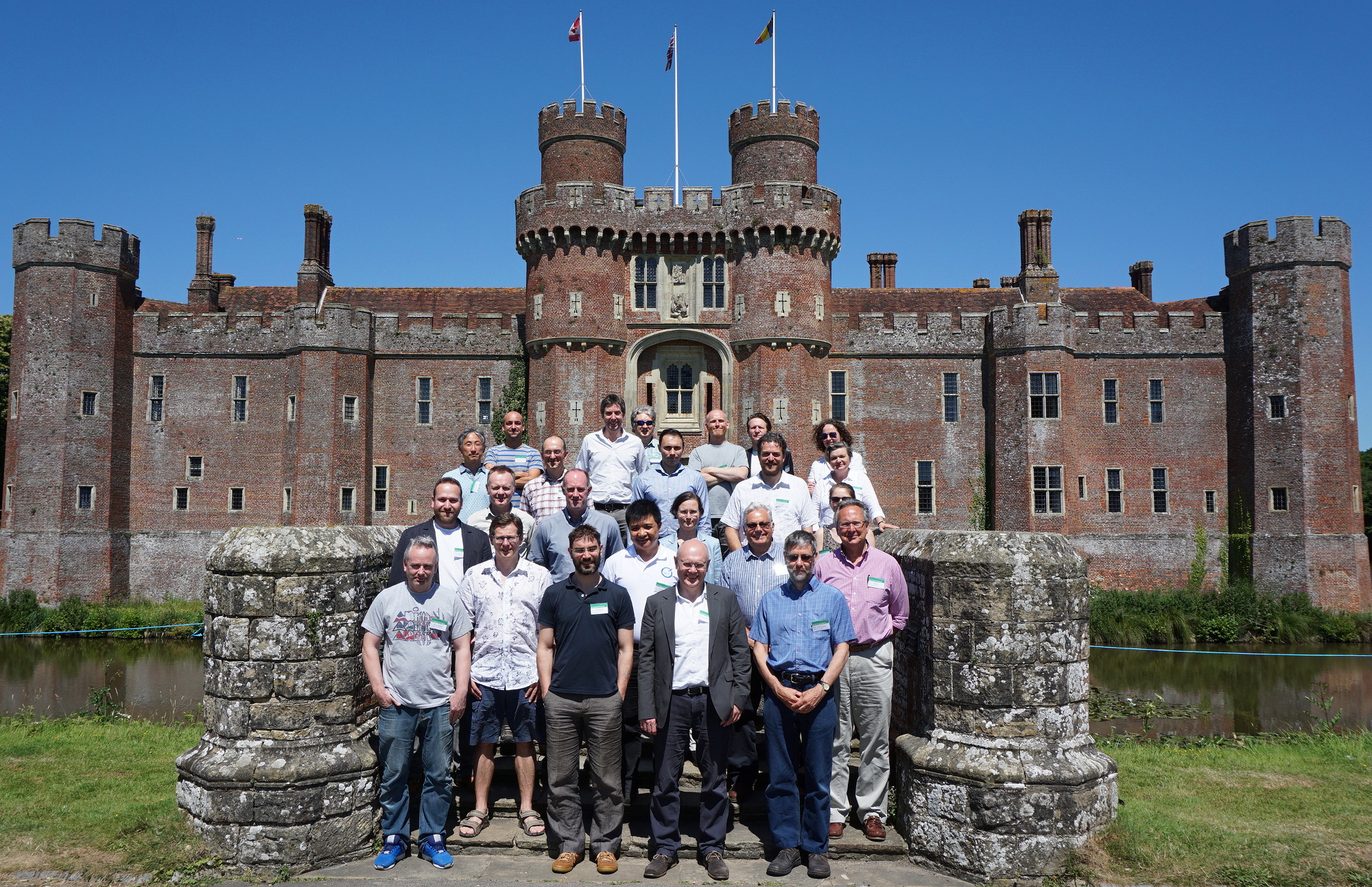
UK Geodesy Meeting Hosted at SGF, Herstmonceux
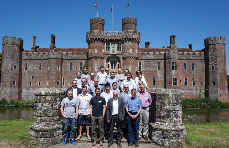
UK Geodesy Workshop Attendees outside Herstmonceux Castle
Geodesists from UK universities, Government bodies and research Facilities came together on 18-19 July 2016 for a two-day Workshop at the BADER International Study Centre, Herstmonceux Castle, hosted by the NERC Space Geodesy Facility.
The aim of the Workshop was to review the current status of UK geophysical and geodetic research along with its supporting geodetic infrastructure and to consider UK priorities for the future.
Colleagues from Newcastle, Liverpool, UCL, Leeds, Nottingham and Glasgow universities joined representatives from the British Geological Survey, Ordnance Survey, the UK Hydrographic Office and from SGF Herstmonceux for the meeting.
The outcome from the Workshop will be a short report that will set out clearly a vision for the future of UK geodetic research and infrastructure in order to address the priority scientific areas.
The report can be downloaded here
[6th January 2016]
SGF Absolute Gravimeter Sets Sail for Port of Spain, Onboard the RRS James Cook
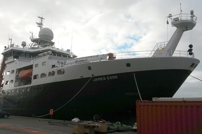
Royal Research Ship James Cook
On a campaign mission first for the SGF, one of our absolute gravimeters is travelling in style to and from Port of Spain, Trinidad and Tobago onboard the NERC research vessel the RRS James Cook.
The gravimeter will arrive in February 2016 where an absolute gravimetry base station will be established.
The base station will provide an important reference for gravity measurements taken on board the RSS James Cook during its cruise.
Where is the RRS James Cook?
[14th November 2015]
SGF Absolute Gravimeter Joins AG Community for Intercomparison
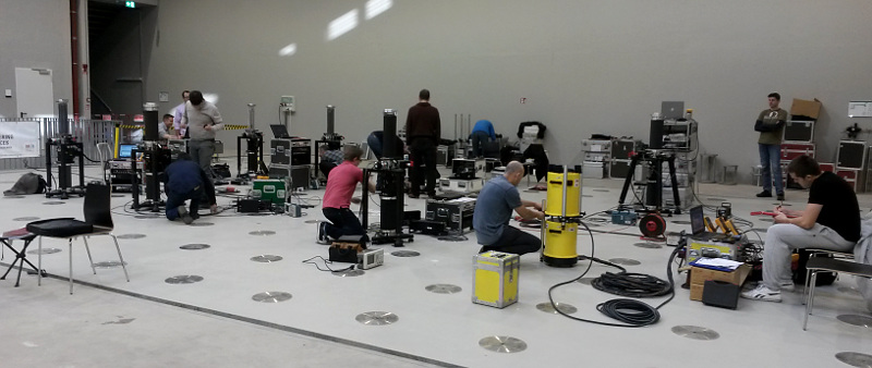
AG intercomparison
The SGF FG5-X absolute gravimeter, normally installed in the facility basement, attended an international comparison of gravimeters at the new Belval campus of the University of Luxembourg in early November.
Over two weeks eighteen gravimeters from all over the world took part in the comparison.
The aim is to determine if each gravimeter is operating correctly and has no relative systematic bias in measurement.
The data from each instument was submitted to the event organisers for analysis, who will report back with the results.
The event was covered by the Luxembourg news channel RTL (+13 mins).
[29th April 2015]
PhD Opportunity at the SGF to Study the Elasticity of the Solid Earth
The BGS Doctoral Training Partnerships scheme is offering a PhD opportunity to graduates in collaboration with Newcastle University, which will include a placement at the NERC Space Geodesy Facility.
The study project is titled "Tidal deformation and solid Earth rheological parameters from GPS/GLONASS geodesy" and will involve close study of the vibrations and deformations of the Earth using the historical GPS and GLONASS datasets collected from hundreds of sites around the world.
Further study into tidal deformation will be made possible using the absolute gravimetry dataset collected at the SGF since 2006.
See here for more information http://www.bgs.ac.uk/research/bufi/vacancies.html
[31st May 2013]
British Geological Survey logo
SGF Joins the British Geological Survey
In April 2013 the NERC Space Geodesy Facility transferred management to the British Geological Survey, BGS.
The facility and its staff are now part of Earth Hazards and Observatories research theme which covers the monitoring of earthquakes, geomagnetism, volcanology, space weather, glaciers and landslides.
Dynamic processes in the Earth's core, mantle, and crust, and the space environment surrounding our planet are studied to understand hazards to life, the environment, and economic infrastructure.
This will enable better forecasts to be made of earthquake occurrence and volcanic eruptions, and of related hazards including tsunamis.
Scientific knowledge is translated into information and risk analyses to assist decision makers in their task of developing adaptation and mitigation strategies to minimise harm.
The SGF contributes to the International Terrestrial Reference Frame (ITRF) which is defined by geodetic techniques, such as satellite laser ranging, to millimetre precision and represents the dynamic Earth.
In addition, the ITRF enables techniques, such as SLR and GNSS operated at the SGF, to support satellite missions monitoring the dynamic processes of the Earth system.
[28th March 2013]
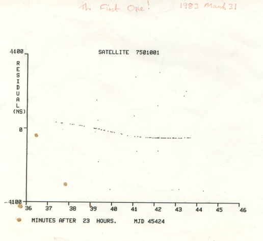
Data sheet showing the first satellite returns.
30 years of SLR at Herstmonceux!
The night of March 31st / April 1st 2013 marks the thirtieth anniversary of the first successful satellite laser range measurements at Herstmonceux.
The plot, a scan of the original paper copy of the realtime output, shows the 'track' of returns from the French geodetic satellite Starlette.
Each point on the smooth track is the result of a time-tagged detection of photons reflected from the satellite; the tracking computer forms the difference in time between each detected event and the expected return time based on the measured time of emission of the laser pulse and the predicted range to Starlette.
The smoothness of the track of these "observed-computed" (O-C) values confirms the reality of the events, and differentiates them from the few random points on the plot, which are the results of detections of noise photons from the sky.
The amplitude of the track, from some +500 to -200ns, equivalent to about 100m in total, results from uncertainty both in the predicted position of the satellite and in the assumed coordinates of the laser ranging station.
The scatter in the O-C values is equivalent to a single-shot range uncertainty of 3.5cm, state of the art in 1983.
A couple of hours later laser returns were obtained from the primary geodetic satellite LAGEOS, and over the next few months the technique was tuned in order to achieve daytime ranging, essential for the station to make a full contribution to international satellite geodesy.
Both satellites remain in orbit and are still tracked today - 30 years later!
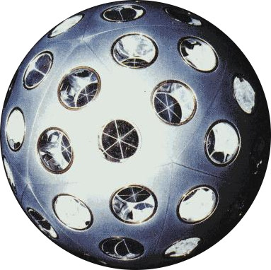
Starlette - the first satellite tracked at Herstmonceux.
The satellite laser ranging capability was developed in the early 1980s by the Royal Greenwich Observatory at Herstmonceux under the direction of the project scientist Dr Andy Sinclair and in collaboration with the University of Hull.
The technique was the next step in international efforts to monitor the Earth's variable rotation and polar motion, a task hitherto undertaken by optical observations of stars such as by the RGO's photographic zenith tube; laser ranging offered at least an order of magnitude improvement in determining these geophysically-related properties of the Earth.
The impetus for the development of the RGO's own SLR system was so that RGO's Space Geodesy Group could take part in an international programme to Monitor Earth Rotation and Intercompare Techniques (MERIT), the main year-long campaign for which began in October 1983.
The MERIT programme, largely directed by Dr George Wilkins, almanacs division head at RGO, resulted in the optical techniques being superseded by SLR and geodetic VLBI, and paved the way to today's highly accurate and rapidly-available measurement of polar motion and length-of-day.
Of course the SLR technique now addresses a wide range of Earth science both through its impact on the realisation of a very accurate terrestrial reference frame and through range observations of several Earth observation satellites in support of precise orbit determination.
[1st December 2012]
Upgraded Gravimeter FG-5X arrives back on site
The absolute gravimeter (AG) has returned to the SGF from its manufacturers Micro-G LaCoste in Colorado, US after being upgraded to the new FG-5X model, with improved dropping chamber and electronic interface.
The upgrade process began with a trip to Walferdange in Luxembourg in June 2012.
Deep inside an old mine there is little local vibration, providing the perfect place for AG calibrations.
Once back home the AG was packed up and sent of the US for its upgrade.
The new dropping chamber is 65% longer in distance, 30% longer in time than a standard FG5.
It has a redesigned drive system with reduced mechanical recoil and reduced horizontal Coriolis accelerations.
The unit is operational and is being tested on the SGF primary pier before it goes back into normal operation.
A new calibration is planned to take place in Luxembourg in November 2013 to test for an absolute change in measurement, which might affect the gravimetry time series.
[28th February 2012]
SGF awarded by GGOS 'New Technology' status
The Global Geodetic Observing System (GGOS) has awarded the SGF the status of 'New Technology SLR Site'.
GGOS is the Observing System of the International Association of Geodesy (IAG).
It works to integrate and coordinate geodetic activities and infrastructure globally so to meet the observational requirements to determine a stable, accurate and global reference frame.
This function is crucial for all Earth observation and many practical applications.
The most demanding requirements come from monitoring the water cycle at global to regional scales and monitoring and modelling sea-level and ice-mass changes in order to detect global change signals in the Earth system.
The SGF was recognised as having a history of robust contribution to the realisation of the SLR and GNSS networks, and hence to space geodesy data and products.
System upgrades, such as the kHz SLR system, the hydrogen-maser-based time reference and new detection system, were highlighted, as was the added co-location of absolute gravity measurements which will play a key role in understanding the motions in the vertical component.
Facilities such as the SGF, as part of ground networks built and operated through international cooperation will be essential in meeting the challenging goals set by GGOS.
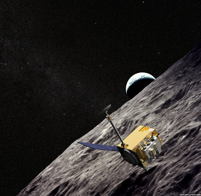
[1st January 2010]
The NERC Space Geodesy Facility has successfully tracked the NASA Lunar Reconnaissance Orbiter (LRO) orbiting the moon over 350,000km away!
To track LRO, the SGF uses a one-way measurement.
The laser pulse is fired by the SGF and recorded by a detector onboard the satellite.
The observer uses a mission-driven web interface which displays data from the satellite in near-real time to correct for the pointing of the telescope and to synchronise the laser fires with the spinning detector onboard the satellite.
Each laser fire epoch from Herstmonceux is transmitted to the NASA mission where it is matched with the LRO-recorded detection in order to determine the range to the satellite to a precision of about 10cm.
The LRO was launched from Cape Canaveral in June 2009, and a few days later reached a two-hour elliptical orbit that takes it from 30 to 200km above the lunar surface.
The mission aims to conduct research targeted specifically at preparing for and supporting future human exploration of the Moon. Among its tasks is accurately measuring the Moon's complex gravity field and mapping its surface at high resolution.
Read the NERC Planet Earth online article
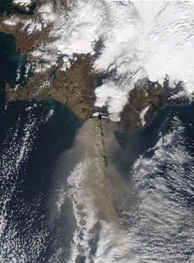
[18th April 2010]
On April 2010 an Icelandic volcano called Eyjafjallajökull erupted, sending a plume of volcanic dust and ash up into the atmosphere over most of the European continent.
The ash was considered to be a hazard to jet engines and the UK and European skies were closed to all such aircraft, causing great disruption to those planning to travel and who were overseas at the time.
Scientists at the Space Geodesy Facility at Herstmonceux in East Sussex interrupted for short, frequent periods the satellite laser ranging schedules in order to use the laser in LIDAR-mode to test the transparency of the atmosphere.
LIDAR observations began a day before the ash cloud was expected to arrive over the South East of England and then routinely every hour.
Height-resolved laser-backscatter intensity is used to infer the presence of haze, con-trails and other aerosols.
The results, communicated to the UK Meteorological Office in Exeter immediately after data processing, showed structured layers of aerosols at heights of 1-2 km, almost certainly associated with the ash plume; the layers were particularly intense on 18th April 2010.
These observations, which are continuing, are being used by the Met Office to test their prediction models, which then inform air-traffic policy.
BGS Recognised as a UN-GGCE Partner
The British Geological Survey has been accepted as
The UN-GGCE Partnership Program was launched in June 2024 to recognize the exceptional commitment and significant contributions Member States, universities and organizations have made to the science of geodesy and strengthening the global geodesy supply chain.
In 2015, the United Nationas General Assembly adopted resolution 69/266 entitled 'A Global Geodetic Reference Frame for Sustainable Development'. The resolution recognizes the economic and scientific importance of an accurate and stable global geodetic reference frame that allows the interrelationship of measurements taken anywhere on the Earth and in space, combining geometric positioning and gravity field-related observations.
The United Nations initiative on Global Geospatial Information Management (UN-GGIM) recognises the growing need for a high quality and sustainable Global Geodetic Reference Frame (GGRF) to support policy and decision-making for inclusive social progress, environmental sustainability and economic development.
BGS operates a ground observatory at the Space Geodesy Facility, Herstmonceux, which provides critical data and analysis products, including satellite laser ranging, GNSS and absolute gravimetry, to the International Association of Geodesy.
Testing Quantum Gravity Sensors
In collaboration the Quantum Technologies Hub in Sensors and Timing with the University of Birmingham the SGF is working to improve our geodetic data output from our gravity sensors by the removal of hydrological influences on the data. The SGF will be testing new quantum gravity sensors as part of a research grant from EPSRC/NERC.
The testing is important in understanding characteristics/capabilities of the new sensors, such as drift, accuracy and precision, and is essential in developing these sensors.
LARES-2 Launched and SLR Tracking Begins!
Credit: CNES/ESA/Arianespace/Optique Vidéo CSG/P. Baudon
The LAser RElativity Satellite 2, or LARES-2, from ASI (Italian Space Agency) follows on from the first LARES mission, which orbits at a much lower height of 1450 km, and the two LAGEOS satellites.
LARES-2 was positioned with an orbital inclination that is the supplement of that of the LAGEOS satellite so that the combination of observations will better reveal the frame-dragging Lense-Thirring effect.
As with the other geodetic satellites orbitting the Earth, LARES-2 is covered in retro-reflectors. These have been designed to have a small satellite signature and to reduce thermal variations.
The SGF, Herstmonceux was one of 5 SLR stations that were able to track this new target within the first few days after launch, using less accurate orbit predictions calculated from radar tracking.
The SGF Analysis Centre generates precise orbit predictions for a list of ILRS satellites and once SLR data became available for LARES-2 the AC was able to generate highly accurate predictions to support the global laser ranging community to acquire routine SLR data for this new target. These orbits are generated daily and the SGF has been the primary prediction supplier for the first 2 months of this scientific mission.
With the global tracking network supplying a strong data stream, the AC plans to investigate the inclusion of the new satellite into its research on improving the definition of the global reference frame, including solutions for long-wavelength terms of the Earth’s gravity field.
A full report of the science behind this new satellite and the involvement of the SGF is available here.
Dr Graham Appleby Talks Geodesy
Dr Graham Appleby, formally Head of the Space Geodesy Facility, gave an online talk to colleagues at the
British Geological Survey. Watch it here.He talks about the history of studying the size and shape of the Earth and how the launching of Earth orbiting satellites resulted in highly accurate techniques for these studies.
Dr Appleby discusses the work of the SGF, the geodetic techniques that contribute to the formation of the Earth's reference frame, a variety of results from analysis and the impact of Geodesy on society.
Watch it here.
NERC National Capability Commissioning – Services & Facilities. Outcome
As a part of Services and Facilities (S&F) commissioning, NERC Council requested a review of the provision of NERC Earth Observation (EO). NERC Executive then commissioned an independent review of the value provide by Space Geodesy Facility (SGF) to the UK community and international partnerships. The outcome of this review concluded that NERC should continue to support the SGF.
An additional recommendation from the review is that the SGF should be reclassified under the National Capability-National and Public Good (NC-NPG) funding stream. It was recognised that the SGF more closely aligns to the characteristics of NC-NPG.
Therefore, NERC proposes that the SGF move from S&F to NC-NPG from 1 April 2018. From this time the SGF will no longer be part of NERC’s S&F portfolio. Overall facility management of the SGF will remain with BGS.
UK Geodesy Meeting Hosted at SGF, Herstmonceux
UK Geodesy Workshop Attendees outside Herstmonceux Castle
The aim of the Workshop was to review the current status of UK geophysical and geodetic research along with its supporting geodetic infrastructure and to consider UK priorities for the future.
Colleagues from Newcastle, Liverpool, UCL, Leeds, Nottingham and Glasgow universities joined representatives from the British Geological Survey, Ordnance Survey, the UK Hydrographic Office and from SGF Herstmonceux for the meeting.
The outcome from the Workshop will be a short report that will set out clearly a vision for the future of UK geodetic research and infrastructure in order to address the priority scientific areas.
The report can be downloaded here
SGF Absolute Gravimeter Sets Sail for Port of Spain, Onboard the RRS James Cook
Royal Research Ship James Cook
The gravimeter will arrive in February 2016 where an absolute gravimetry base station will be established.
The base station will provide an important reference for gravity measurements taken on board the RSS James Cook during its cruise.
Where is the RRS James Cook?
SGF Absolute Gravimeter Joins AG Community for Intercomparison
AG intercomparison
Over two weeks eighteen gravimeters from all over the world took part in the comparison.
The aim is to determine if each gravimeter is operating correctly and has no relative systematic bias in measurement. The data from each instument was submitted to the event organisers for analysis, who will report back with the results.
The event was covered by the Luxembourg news channel RTL (+13 mins).
PhD Opportunity at the SGF to Study the Elasticity of the Solid Earth
The BGS Doctoral Training Partnerships scheme is offering a PhD opportunity to graduates in collaboration with Newcastle University, which will include a placement at the NERC Space Geodesy Facility.
The study project is titled "Tidal deformation and solid Earth rheological parameters from GPS/GLONASS geodesy" and will involve close study of the vibrations and deformations of the Earth using the historical GPS and GLONASS datasets collected from hundreds of sites around the world.
Further study into tidal deformation will be made possible using the absolute gravimetry dataset collected at the SGF since 2006.
See here for more information http://www.bgs.ac.uk/research/bufi/vacancies.html
British Geological Survey logo
SGF Joins the British Geological Survey
In April 2013 the NERC Space Geodesy Facility transferred management to the British Geological Survey, BGS. The facility and its staff are now part of Earth Hazards and Observatories research theme which covers the monitoring of earthquakes, geomagnetism, volcanology, space weather, glaciers and landslides.
Dynamic processes in the Earth's core, mantle, and crust, and the space environment surrounding our planet are studied to understand hazards to life, the environment, and economic infrastructure. This will enable better forecasts to be made of earthquake occurrence and volcanic eruptions, and of related hazards including tsunamis. Scientific knowledge is translated into information and risk analyses to assist decision makers in their task of developing adaptation and mitigation strategies to minimise harm.
The SGF contributes to the International Terrestrial Reference Frame (ITRF) which is defined by geodetic techniques, such as satellite laser ranging, to millimetre precision and represents the dynamic Earth.
In addition, the ITRF enables techniques, such as SLR and GNSS operated at the SGF, to support satellite missions monitoring the dynamic processes of the Earth system.
Data sheet showing the first satellite returns.
30 years of SLR at Herstmonceux!
The night of March 31st / April 1st 2013 marks the thirtieth anniversary of the first successful satellite laser range measurements at Herstmonceux.
The plot, a scan of the original paper copy of the realtime output, shows the 'track' of returns from the French geodetic satellite Starlette. Each point on the smooth track is the result of a time-tagged detection of photons reflected from the satellite; the tracking computer forms the difference in time between each detected event and the expected return time based on the measured time of emission of the laser pulse and the predicted range to Starlette. The smoothness of the track of these "observed-computed" (O-C) values confirms the reality of the events, and differentiates them from the few random points on the plot, which are the results of detections of noise photons from the sky.
The amplitude of the track, from some +500 to -200ns, equivalent to about 100m in total, results from uncertainty both in the predicted position of the satellite and in the assumed coordinates of the laser ranging station. The scatter in the O-C values is equivalent to a single-shot range uncertainty of 3.5cm, state of the art in 1983.
A couple of hours later laser returns were obtained from the primary geodetic satellite LAGEOS, and over the next few months the technique was tuned in order to achieve daytime ranging, essential for the station to make a full contribution to international satellite geodesy. Both satellites remain in orbit and are still tracked today - 30 years later!
Starlette - the first satellite tracked at Herstmonceux.
The impetus for the development of the RGO's own SLR system was so that RGO's Space Geodesy Group could take part in an international programme to Monitor Earth Rotation and Intercompare Techniques (MERIT), the main year-long campaign for which began in October 1983. The MERIT programme, largely directed by Dr George Wilkins, almanacs division head at RGO, resulted in the optical techniques being superseded by SLR and geodetic VLBI, and paved the way to today's highly accurate and rapidly-available measurement of polar motion and length-of-day. Of course the SLR technique now addresses a wide range of Earth science both through its impact on the realisation of a very accurate terrestrial reference frame and through range observations of several Earth observation satellites in support of precise orbit determination.
Upgraded Gravimeter FG-5X arrives back on site
The upgrade process began with a trip to Walferdange in Luxembourg in June 2012. Deep inside an old mine there is little local vibration, providing the perfect place for AG calibrations. Once back home the AG was packed up and sent of the US for its upgrade.
The new dropping chamber is 65% longer in distance, 30% longer in time than a standard FG5. It has a redesigned drive system with reduced mechanical recoil and reduced horizontal Coriolis accelerations.
The unit is operational and is being tested on the SGF primary pier before it goes back into normal operation. A new calibration is planned to take place in Luxembourg in November 2013 to test for an absolute change in measurement, which might affect the gravimetry time series.
SGF awarded by GGOS 'New Technology' status
GGOS is the Observing System of the International Association of Geodesy (IAG). It works to integrate and coordinate geodetic activities and infrastructure globally so to meet the observational requirements to determine a stable, accurate and global reference frame.
This function is crucial for all Earth observation and many practical applications. The most demanding requirements come from monitoring the water cycle at global to regional scales and monitoring and modelling sea-level and ice-mass changes in order to detect global change signals in the Earth system.
The SGF was recognised as having a history of robust contribution to the realisation of the SLR and GNSS networks, and hence to space geodesy data and products. System upgrades, such as the kHz SLR system, the hydrogen-maser-based time reference and new detection system, were highlighted, as was the added co-location of absolute gravity measurements which will play a key role in understanding the motions in the vertical component.
Facilities such as the SGF, as part of ground networks built and operated through international cooperation will be essential in meeting the challenging goals set by GGOS.
The NERC Space Geodesy Facility has successfully tracked the NASA Lunar Reconnaissance Orbiter (LRO) orbiting the moon over 350,000km away!
To track LRO, the SGF uses a one-way measurement. The laser pulse is fired by the SGF and recorded by a detector onboard the satellite. The observer uses a mission-driven web interface which displays data from the satellite in near-real time to correct for the pointing of the telescope and to synchronise the laser fires with the spinning detector onboard the satellite. Each laser fire epoch from Herstmonceux is transmitted to the NASA mission where it is matched with the LRO-recorded detection in order to determine the range to the satellite to a precision of about 10cm.
The LRO was launched from Cape Canaveral in June 2009, and a few days later reached a two-hour elliptical orbit that takes it from 30 to 200km above the lunar surface. The mission aims to conduct research targeted specifically at preparing for and supporting future human exploration of the Moon. Among its tasks is accurately measuring the Moon's complex gravity field and mapping its surface at high resolution.
Read the NERC Planet Earth online article
On April 2010 an Icelandic volcano called Eyjafjallajökull erupted, sending a plume of volcanic dust and ash up into the atmosphere over most of the European continent.
The ash was considered to be a hazard to jet engines and the UK and European skies were closed to all such aircraft, causing great disruption to those planning to travel and who were overseas at the time.
Scientists at the Space Geodesy Facility at Herstmonceux in East Sussex interrupted for short, frequent periods the satellite laser ranging schedules in order to use the laser in LIDAR-mode to test the transparency of the atmosphere. LIDAR observations began a day before the ash cloud was expected to arrive over the South East of England and then routinely every hour.
Height-resolved laser-backscatter intensity is used to infer the presence of haze, con-trails and other aerosols. The results, communicated to the UK Meteorological Office in Exeter immediately after data processing, showed structured layers of aerosols at heights of 1-2 km, almost certainly associated with the ash plume; the layers were particularly intense on 18th April 2010. These observations, which are continuing, are being used by the Met Office to test their prediction models, which then inform air-traffic policy.