Show Posts

This section allows you to view all posts made by this member. Note that you can only see posts made in areas you currently have access to.


Topics - Matt Wilkinson

Pages: [1] 2
1
Data and Software Questions / OrbitNP.py - New Release 1.2
« on: January 04, 2022, 10:22:57 AM »
A new version of the orbit adjustment and normal point formation software, orbitNP.py, is now available through the ILRS software webpage  https://ilrs.cddis.eosdis.nasa.gov/technology/software

This software is designed to work for all SLR stations to compute range residuals and form ILRS normal points. It can be installed and used for comparisons at stations.

ILRS full-rate data files can also be used to inspect the SLR measurements for any satellite pass for any station and repeat the normal point calculation. 

The update contains many refinements and new features and these are listed below. 

Please update to this version and also consult the README file. If you have a questions, issues or suggestions you can post them in the comments below. 

With regards
Matt

 
###
# Update History
###

Version 1.1
    --    Added import of warnings Python3 module
    --    New method for cal2mjd() and mjd2cal()
    --    Include option for full CRD normal point output file.
    --    Include 1st iteration quick-pass option to prevent high density segments dominating pass fit.
    --    Include input of 'System Configuration ID'.
    --    Adjusted method for gauss fit to front of residual distribution.
    --    Allow for disagreement in first epoch and H4 record.
    --    Station coordinates and velocities taken from an ILRS SINEX solution file
    --    Peak-Mean calculated using a tangent fit to a smoothed profile.
    --    Option to include unfiltered range measurements

   
Version 1.2
    --    Gauss fit filter added.
    --    Peak-Mean default as 1*sigma iterative mean.
    --    Option to calculate a '50' record if not included in full-rate CRD file.
    --    Include option to output final ranges in CRD format with met and calibration values.
    --    Filtering at two levels. The first is to form the normal points and the second is to include in the full-rate output
    --    Include option to input satellite centre of mass offset to improve the orbit solution and flatten range residuals.
    --    Indicate if individual normal point residual bins have slopes.
    --    Select SLR station data in full-rate data file from list.
    --    Matplotlib figure window now kept open to allow for much faster plotting of a series of passes.
 

2
Station Equipment Questions / Infrared thermal usb camera
« on: November 05, 2019, 11:36:55 AM »
Hi
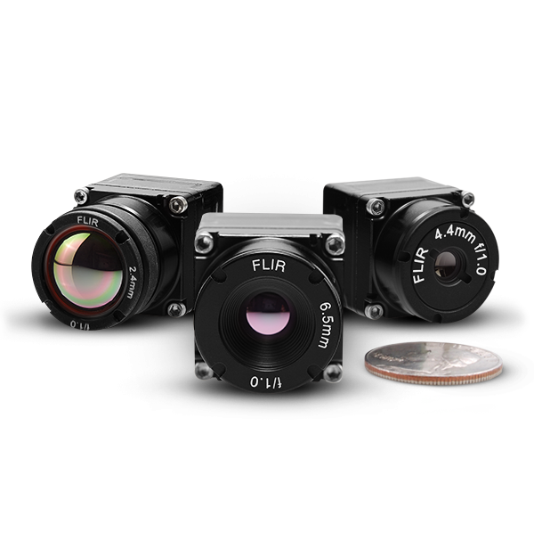
At the recent Technical Workshop in Stuttgart, we heard from a number of people operating infrared cameras.  The reports were encouraging but the cameras are expensive. Could i ask what people on here think of these cheaper cameras?:

https://www.flir.co.uk/products/boson/?model=20640A012
    Longwave infrared; 7.5 µm – 13.5 µm
    640 x 512
    60Hz
    12 µm pixel

Thanks!

3
Data and Software Questions / CRDv2 experience (as a provider)
« on: October 07, 2019, 01:18:10 PM »
How are you getting on with generating version 2 CRD SLR data files?

At Herstmonceux, we are about to start submitting our data in CRDv2 format. I wrote a Python script to generate the files following a similar method to how we write the CRDv1 files in FORTRAN.

It wasn't too much trouble and i think it is all correct now. If you have not looked at doing this yet, there are changes to be aware of in some of the fields and there are also additional fields:
  • H5 Prediction Header
  • C5 Software Configuration
  • C6 Meteorological Instrumentation Configuration
  • C7 Calibration Target Configuration *new*
  • 41 Calibration Detail Record
  • 42 Calibration "Shot" Record *new*

One major change is the recording of the calibration records.  In the v2 version only one '40' record should be included with additional calibrations recorded as '41'.  The epoch of the '40' record should be the at the middle of the pass segment and the calibration value determined from pre and post measurements.

See the latest CRDv2 document from the ILRS website: https://ilrs.cddis.eosdis.nasa.gov/data_and_products/formats/crd.html

It was clear to me in doing this that more data can be included in the CRD files than we are providing at Herstmonceux.  In time, i will look at including the '30' records for Pointing angles.

We also don't collect the information requested in the '21' Meteorological Supplement Record. Is anyone collecting this information?:
  • Wind speed (m/s)
  • Wind direction (degrees azimuth, North is zero)
  • Weather conditions (two-digit SYNOP/WMO “present weather” code, or “rain”, “snow”, “fog”, “mist”, “clear”, “na”, etc.)
  • Visibility (km)
  • Sky clarity (i.e., zenith extinction coefficient)
  • Atmospheric seeing (arcsec)
  • Cloud cover (%)
  • Sky temperature in degrees Kelvin
We do however collect visibility values and so i will look in to including this in the future. Is there an instrument that anyone is using that reliably provides the rest of this information?

Please share your experience in providing CRDv2 below. Any questions or advice welcome

Thanks

4
Mission Tracking Feedback / Recovered: Radioastron
« on: June 14, 2019, 02:18:14 PM »

Lavochkin Association did not manage to establish communication with the Spectr-R satellite. Attempts continued from 10 January to 30 May 2019. The State Commission examined the satellite’s technical condition on 30 May 2019 and decided to finish the RadioAstron observing program. The satellite successfully operated for 7.5 years instead of the originally planned 3 years. The link with the satellite was lost due to the very long exposure to the space radiation which has affected the onboard low-gain antenna communication system. Currently, the Astro Space Center is completing the data transfer, correlation and archiving of the vast amount of unique scientific data. International science teams continue to process, analyze and publish the results.

5
Open a Discussion / Recovered: 'Space debris EU-ESA agreement'
« on: June 14, 2019, 02:17:24 PM »
Good morning.
How is it going to affect our community this new in relation with space debris applications?
https://www.esa.int/Our_Activities/Space_Safety/ESA_and_the_United_Nations_team_up_for_space_debris

We are designing our new station in order to be compatible with space debris activities in the future if it is necessary.
BR

6
Dear Laser Tracking Colleagues,

G'Day from Tokyo.

In the 21st International Workshop on Laser Ranging (conference site: http://www.iwlr2018.serc.org.au/, proceedings site: https://cddis.nasa.gov/lw21/Program/index.html, I presented station-by-station performance charts (printed on 1-metre-long sheets) during the Clinic Session 3 co-hosted with Jose Rodriguez.  Here are the short summary of the analysis and the links to the charts.

Period: July 2017 to June 2018.
Satellites: LAGEOS-1, LAGEOS-2, AJISAI, STARLETTE, STELLA and LARES.
29 Stations with > 200 LAGEOS passes in the 1 year span.
More details about the analysis: See http://geo.science.hit-u.ac.jp/slr/bias/2018sp/Clinic_Booth3.pdf

Unlike the previous years' ones, this year's charts are organised PER STATION.  Matrix charts are also provided (printed on the reservse side) to help investigate the cause.

The first part contains:
  Residual wrt Range rate (negative in ascending (first) half, and positive in descending (second) half of a pass)
  Residual wrt Local time (defined by the station longitude, slightly different from the local standard time)
  Residual wrt Range rate (as specified in normal point data)
  Residual wrt Single-shot RMS (as specified in normal point data)
  Residual wrt Skew (as specified in normal point data)
  Residual wrt Kurtosis (as specified in normal point data)
  Residual wrt System delay (1), (2),.. (per system delay 'group')
  System delay (all sat) (including calibration data for other satellites not included in this analysis)
  System delay (A), (B), ... (vertical scale magnified as above)
  Calibration interval (cumulative) (typical calbration interval is at median (50%))

The matrix chart (second  part) labels, top-to-botumn = left-toright,  mean:
  Mon 17: Months from January 2017 (13 for January 2018)
  Hour: Local time
  # ret: Number of returns per NP bin
  Return rate
  RMS: Single-shot RMS
  Skew
  Kurt: Kurtosis
  Range rate
  System delay (1), (2), ...
  O-C: POD residuals
 
7090 (Yarragadee) http://geo.science.hit-u.ac.jp/slr/bias/2018sp/7090.png,  http://geo.science.hit-u.ac.jp/slr/bias/2018sp/c7090-a.png
7941 (Matera)  http://geo.science.hit-u.ac.jp/slr/bias/2018sp/7941.png,  http://geo.science.hit-u.ac.jp/slr/bias/2018sp/c7941-a.png
7825 (Mt Strolmo)  http://geo.science.hit-u.ac.jp/slr/bias/2018sp/7825.png,  http://geo.science.hit-u.ac.jp/slr/bias/2018sp/c7825-a.png
7237 (Changchun) http://geo.science.hit-u.ac.jp/slr/bias/2018sp/7237.png,  http://geo.science.hit-u.ac.jp/slr/bias/2018sp/c7237-a.png
7105 (Greenbelt) http://geo.science.hit-u.ac.jp/slr/bias/2018sp/7105.png,  http://geo.science.hit-u.ac.jp/slr/bias/2018sp/c7105-a.png
7810 (Zimmerwald) http://geo.science.hit-u.ac.jp/slr/bias/2018sp/7810.png,  http://geo.science.hit-u.ac.jp/slr/bias/2018sp/c7810-a.png
7840 (Herstmonceux) http://geo.science.hit-u.ac.jp/slr/bias/2018sp/7840.png,  http://geo.science.hit-u.ac.jp/slr/bias/2018sp/c7840-a.png
7110 (Monument Peak) http://geo.science.hit-u.ac.jp/slr/bias/2018sp/7110.png,  http://geo.science.hit-u.ac.jp/slr/bias/2018sp/c7110-a.png
7501 (Hartebeesthoek) http://geo.science.hit-u.ac.jp/slr/bias/2018sp/7501.png,  http://geo.science.hit-u.ac.jp/slr/bias/2018sp/c7501-a.png
7841 (Potsdam) http://geo.science.hit-u.ac.jp/slr/bias/2018sp/7841.png,  http://geo.science.hit-u.ac.jp/slr/bias/2018sp/c7841-a.png
7821 (Shanghai) http://geo.science.hit-u.ac.jp/slr/bias/2018sp/7821.png,  http://geo.science.hit-u.ac.jp/slr/bias/2018sp/c7821-a.png
8834 (Wettzell) http://geo.science.hit-u.ac.jp/slr/bias/2018sp/8834.png,  http://geo.science.hit-u.ac.jp/slr/bias/2018sp/c8834-a.png
7839 (Graz) http://geo.science.hit-u.ac.jp/slr/bias/2018sp/7839.png,  http://geo.science.hit-u.ac.jp/slr/bias/2018sp/c7839-a.png
7119 (Haleakala) http://geo.science.hit-u.ac.jp/slr/bias/2018sp/7119.png,  http://geo.science.hit-u.ac.jp/slr/bias/2018sp/c7119-a.png
7819 (Kunming) http://geo.science.hit-u.ac.jp/slr/bias/2018sp/7819.png,  http://geo.science.hit-u.ac.jp/slr/bias/2018sp/c7819-a.png
1887 (Baikonur) http://geo.science.hit-u.ac.jp/slr/bias/2018sp/1887.png,  http://geo.science.hit-u.ac.jp/slr/bias/2018sp/c1887-a.png
7838 (Shimosato) http://geo.science.hit-u.ac.jp/slr/bias/2018sp/7838.png,  http://geo.science.hit-u.ac.jp/slr/bias/2018sp/c7838-a.png
7249 (Beijing) http://geo.science.hit-u.ac.jp/slr/bias/2018sp/7249.png,  http://geo.science.hit-u.ac.jp/slr/bias/2018sp/c7249-a.png
7827 (Wettzell) http://geo.science.hit-u.ac.jp/slr/bias/2018sp/7827.png,  http://geo.science.hit-u.ac.jp/slr/bias/2018sp/c7827-a.png
7407 (Brasilia) http://geo.science.hit-u.ac.jp/slr/bias/2018sp/7407.png,  http://geo.science.hit-u.ac.jp/slr/bias/2018sp/c7407-a.png
1873 (Simeiz) http://geo.science.hit-u.ac.jp/slr/bias/2018sp/1873.png,  http://geo.science.hit-u.ac.jp/slr/bias/2018sp/c1873-a.png
1879 (Altay) http://geo.science.hit-u.ac.jp/slr/bias/2018sp/1879.png,  http://geo.science.hit-u.ac.jp/slr/bias/2018sp/c1879-a.png
7845 (Grasse) http://geo.science.hit-u.ac.jp/slr/bias/2018sp/7845.png,  http://geo.science.hit-u.ac.jp/slr/bias/2018sp/c7845-a.png
1893 (Katzively) http://geo.science.hit-u.ac.jp/slr/bias/2018sp/1893.png,  http://geo.science.hit-u.ac.jp/slr/bias/2018sp/c1893-a.png
1891 (Irkutsk) http://geo.science.hit-u.ac.jp/slr/bias/2018sp/1891.png,  http://geo.science.hit-u.ac.jp/slr/bias/2018sp/c1891-a.png
1868 (Komsomolsk-na-Amure) http://geo.science.hit-u.ac.jp/slr/bias/2018sp/1868.png,  http://geo.science.hit-u.ac.jp/slr/bias/2018sp/c1868-a.png
1889 (Zelenchukskya) http://geo.science.hit-u.ac.jp/slr/bias/2018sp/1889.png,  http://geo.science.hit-u.ac.jp/slr/bias/2018sp/c1889-a.png
1886 (Arkhyz) http://geo.science.hit-u.ac.jp/slr/bias/2018sp/1886.png,  http://geo.science.hit-u.ac.jp/slr/bias/2018sp/c1886-a.png
7811 (Borowiec) http://geo.science.hit-u.ac.jp/slr/bias/2018sp/7811.png,  http://geo.science.hit-u.ac.jp/slr/bias/2018sp/c7811-a.png

Best Regards,
Toshi

7

Today, while writing my own CRD-parsing python3 code, I felt a little bit wheel-reinventing

Since the new CRD/CPF format is going to release at the Canberra meeting, I guess it's time to think about our new CRD2.0 python library?
It should have following functions: verify the CRD2.0 format, extract data, etc.

I found in GitHub the CRD/CPF library from Olli Wilkman:

https://github.com/dronir/SLRdata

Could be a good start.

8
Lasers / Polarisation
« on: April 27, 2018, 10:28:09 AM »
We need to talk about polarisation!

At Herstmonceux, we are still emitting linear polarised laser light after an attempt to make it circular with a 1/4 wave plate failed. The circular polarisation was lost through the coudé mirrors before the beam left the emitter.

Would everyone please describe here the polarisation characteristics of their SLR systems.
  • What is polarisation state of the laser light emitted by your SLR system?
  • How are you achieving this?
  • Have you tested this and know that you are sending what you think you are at all telescope azimuths and elevations?
  • Can you control the emitted polarisation?
  • What are the polarising properties of your receive path [At Hx, we found our receive path to be highly selective to polarisation and we had to replace our dichroic mirror]
In the future, we plan to look further at circular polarisation and would be grateful for any advice from those that are able to send circular polarised light.  We also hope to return to looking at controlling the emitted linear polarisation orientation using a 1/2 wave plate.

Thanks
Matt

9
ILRS Stations / SLR Spring
« on: April 27, 2018, 10:11:55 AM »
Spring at the Herstmonceux SLR station

10
Mission Tracking Feedback / S-NET tracking
« on: April 06, 2018, 03:15:05 PM »
The 4 S-NET (https://ilrs.cddis.eosdis.nasa.gov/missions/satellite_missions/current_missions/snt4_general.html) satellites were launched on February 01, 2018.  They have been difficult targets up to now. At Herstmonceux, we've had a number of unsuccessful attempts. And i think they have not been tracked by any station in the ILRS network.


However, next week (11th April) we expect to begin to see passes that are partially sunlit and so we will hopefully stand a better chance of getting some returns. This must also be true for other stations.

We will focus on S-NET4 as suggested in the recent ilrs-sta mail (https://lists.nasa.gov/pipermail/ilrs-sta/2018-April/005207.html).

Please use this space below to comment on your S-NET attempts, successes and failures over the coming weeks. Good luck!

11
Welcome to the ILRS NESC Forum / Posting a mathematical formula
« on: January 04, 2018, 04:21:59 PM »

To help contributors who want to include formulae in their posts I've installed a program called 'mimetex' which takes LaTeX formatted text and produces a gif image.  It works like this:

[ img]/cgi-bin/mimetex.cgi?f(x)=\int_{-\infty}^xe^{-t^2}dt [/ img]

which without the tag spaces gives:


Please test it out using the post preview.  See here http://www.forkosh.com/mimetex.html

Matt


12
Open a Discussion / MOVED: Satellite BLITS-M
« on: January 04, 2018, 04:11:02 PM »

13
In-Sky Safety / FLARM
« on: January 03, 2018, 09:37:05 AM »
Hi

I'd like to know more about FLARM and what it can offer SLR stations. https://flarm.com/products/powerflarm/

I see the Graz station is using it. Is anyone else?

Despite having a cautionary/avoidance zone for aircraft around the Herstmonceux SLR station, we do get some light aircraft, gliders etc flying over, especially on nice sunny days. This means the observer has to keep a look out.

If this system can raise a proximity alarm then i guess the observer would find it very useful.

Please post your experience. Cheers

14
Hi all

I hope all those who attended had an enjoyable and productive Workshop in Riga.

I'm sorry i wasn't there. And I know I wasn't the only one who couldn't make it.

So, what did i miss?
  • What did you take away from the Workshop?
  • What were the things you learnt?
  • What was of most interest to you?

Please share your thoughts below


Matt

15
Photography / Night Photography
« on: September 21, 2017, 03:20:03 PM »
Herstmonceux and Orion

Pages: [1] 2